Single Screw, Steam Powered, Older steel riveted plate construction
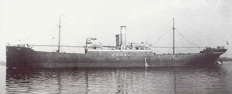
This site is now now know to be MERAK, this info page still posted as it is interesting information
Sunk
off the end of Diamond Shoals near the Diamond Shoals Light Tower
Depth 130 feet
This shipwreck is located very near the Diamond Shoals Light Tower, sitting just a mile and half to the ESE of the structure in 130 feet of water. The identity of this shipwreck site is not yet known. The wreck was first dived in the early 1980s and did not get much attention from wreck divers as at the time it was just a large relatively featureless upside down hull providing no interior access or artifact field to explore. It is located in an area with generally high current (2+ knots on average) and many other more interesting wreck sites are nearby. There are several possible ships that this site may be but there is conflicting information and the site lacks sufficient identifying features to assign a positive identity at this time.
A Likely Candidate
This wreck site may be the remains of the SS Merak, which was sunk during WWI, however there is no absolutely conclusive evidence at this time. There are many things which point to this being the Merak and not the other ships lost in the vicinity, but not yet identified. The first and most compelling is the location of the wreck site. This shipwreck is in the right place to be the Merak and of the same general construction (but so is the other potential candidate). She is about the right tonnage and build, without question steam powered and single screw and her propeller measures the right size and design. Going against the Merak Identification is the lack of large amounts of the coal cargo the Merak was carrying. Unfortunately, the vessel is totally upside down and the coal cargo may be mostly buried and the inversion also conceals all other structures that would assist in a positive identification.
The Merak by one report was said to have run aground in her attempt to flee and this information has been replicated in many reports and books. This scenario is possible, but not all that likely as this fact was not related by crew members during their interrogation by naval authorities after the event. According to Second Mate Monti's testimony, after about thirty shots had been fired at them they knew escape was impossible and the crew abandoned the vessel when the U-boat was still several miles off and had turned attention to the lightship. No mention of a grounding was made during his testimony. In fact during the initial assault on the Merak, the U-boat was actually closer to the Diamond Shoals Lightship than Merak, giving the Merak crew the time and opportunity to launch the boats and flee.
The shipwreck is right where it should be if the reports from the Lightship crew on Merak's location during these events are correct. There were reports the large submarine came alongside the Merak and placed explosives onboard to sink her. Would the experienced U-Boat commander have endangered his vessel in shallow shoal water to do so? Probably not. Also, the wreck is torn right in the engine room with little other damage to the hull. This is the exact location where explosives would be placed to do the most immediate damage to the ship. However, in the report of attack that Fregattenkapitan Waldemar Kophamel filed he reported using a torpedo on the Merak, sinking her in that manner. Either way, his attack report provides a location very near where this ship was sunk.
Another Contender (maybe)
Another possible identity for this shipwreck site is the 5335 ton Panamanian registered tanker SS Olympic. The Olympic was originally built as an ore carrier in 1907 under the name Harport, later renamed the Dayton, finally called Olympic. Along the way, in 1912, she was converted to a tanker. Olympic was lost with all hands at an unknown location off Hatteras to a U-Boat attack on January 22nd, 1942. Ernst Kals in U-130 is often credited with the sinking of Olympic in many records and books about the submarine actions off the US Coast. Some records have actually credited the loss to Reinhardt Hardegan in U-123. However, neither of these U-boats could have sunk the Olympic. Careful examination of the records of the German submarines on patrol in the area, at the time which Olympic would have sailed thru, point to one U-boat as being responsible, U-66, KrvKpt Richard Zapp, who also sunk several other vessels off Hatteras on his patrol.
| The Olympic left Curacao (Netherlands
Antilles off Venezuela) on Jan 13th heading for Baltimore, MD with a load of
oil. Being an old tired vessel, she could only steam at 6 to 7.5 kts.
At that speed, Olympic should have been in the waters offshore of Hatteras on
Jan 22nd. Zapp crossed paths with the Olympic in what he reported to be
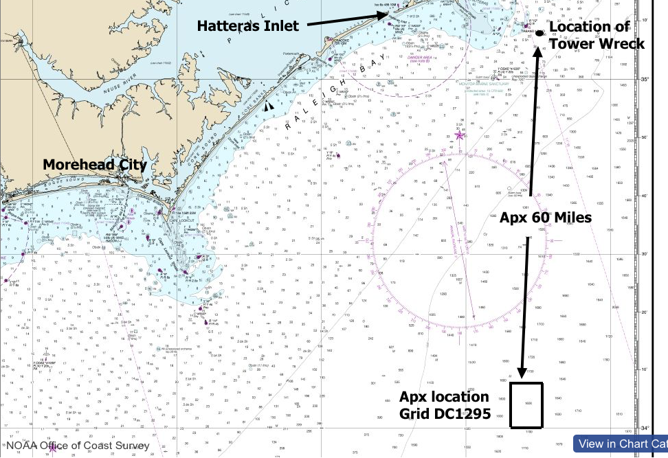
quadrant DC1295 of the German Naval grid chart (apx. 34'03" - 75'18"
is the center point) and
this location is over 60 miles south from the mystery wreck site. Zapp fired two torpedoes
from his stern tubes set to run at 30 knots, 3 meters deep. 124 seconds
later, they struck the tanker and the explosions sent a "moderate bloom up approximately
50 meters high" The Olympic immediately broke clean through in the
middle and was gone in less then two minutes. There were no survivors or distress
calls made, 35 men perished.
The location of the attack on Olympic was not known until after the war as she simply did not show up in port. What is known are the map quadrants reported in Zapp's after action report is a reasonable distance from this wreck site and perhaps close enough to put the SS Olympic into the running for being this wreck. This wreck is of the same general design and construction of the Olympic and very close in size to this ship. There is no sign of cargo in the bow section and there are large open spaces inside the bow section of the hull typical of a tanker, but this is not conclusive proof one way or another as bulk carriers also have large spaces. |
Offshore Chart of the NC coast showing the positions of the Mystery Wreck and the German grid quadrant where Zapp reported sinking Olympic. |
However, going against this location for the wreck of Olympic is that in the after action report by Zapp he states the water depth at the time of the attack to be 5000 meters (2500 fathoms/15000feet) deep. Is this a mistake, or were they off the continental shelf at the time of this attack? The tracks of both the submarine and the tanker would have crossed waters close to this depth prior to making the Diamond Shoals area. I have examined other attack reports from Zapp of vessels he sunk, for which the locations are known, they all reflect accurate water depths and accurate Naval Grids. If this water depth is correct, then Olympic sunk far offshore and then the reported grid quadrant is not in question. Modern charts show the water depths in this grid to be only 1600 fathoms (9600ft) deep. However, historical charts from 1939 have far fewer and less accurate spot soundings and the closet one to the grid shows 2819 fathoms (16,914 feet) which is just over 5,000 meters.
If the wreck proves to be Olympic, then either Olympic floated a long distance in the gulf stream or Zapp's report of his position was in serious error.
A third possibility is that this site is neither of these vessels but some other yet unidentified wrecked vessel. Continued site exploration and perhaps the recovery of an identifiable artifact from the site will lead to a positive identification.
Diving the Shipwreck
| This wreck is in an area
where the current is usually very strong and almost consistently Gulf
Stream. She sits in 120 to 135 feet of water, with the hole at the
stern wash reaching 145. The site is not very far from the
Diamond Shoals Light Tower, and about four miles from the wreck of the
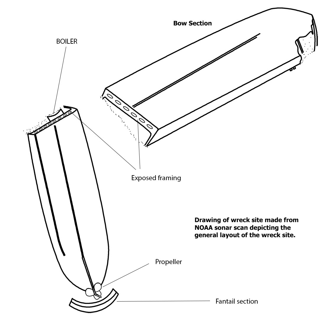
Diamond Shoals Lightship. This wreck site is broken into two large
sections and both of them are completely upside down. These big
pieces of the ship lay perpendicular to each other with a gap of about 60
feet between them, the sections forming roughly an "L".
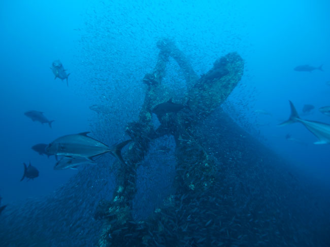
The stern section is the biggest piece and it lays with the single
propeller pointing roughly to the east, the bow section lays 90 degrees to
this with two torn open ends close to each other and the end of the bow
farthest down the dominant current.
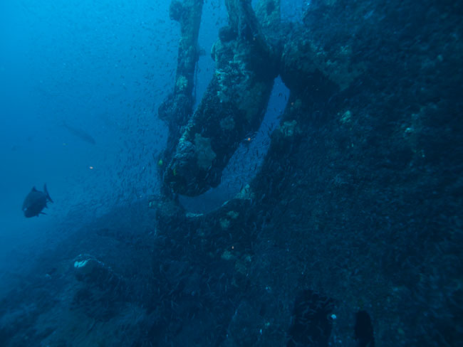
There are no highly distinct features at this wreck site to aide in an easy positive identification. Both sections are completely upside down with the gunnels deep into the sugar white sands of the shoals. There are no remnants of the bridge works or other deck houses as all of these structures are crushed under the upside down hull. |
This is a drawing made by NOAA after their sonar survey of this site. |
|
During early dives to this site back in the 1980s, the hull was a solid structure with no access available to any interior spaces. The hull is broken open at only two places and entry into the ship was not possible in years past. The stern section break is just forward of the boilers and the twin boilers lay side by side just inside the hull. The boilers are almost totally sanded in exposing only a small amount of their diameter and of course being upside down, what is exposed are the very bottom of the boilers. Looking into this section, other machinery is visible but not easily accessible and it will be a very tight squeeze to get back into the area of the machinery. The bow section break provides great access but has yet to provide anything of significance to allow identification. The hull which is of riveted plate construction, has two bilge keels that run the length of the hull protruding out about six to eight inches ending near the stern where the single four blade prop is the dominant feature. The rudder has fallen from the gudgeons and is laying in the sand below the prop. The broad curve of the fantail is very evident looking down from the end of the rudder stock. There are small areas where the shell plating is rotted away between the framing but I have seen nothing of importance in these small openings. However, in recent years these openings have become larger and will allow entry into the hull if one is very careful. Is she the Merak, Olympic or some other unlucky vessel? The answer is not known with absolute certainty, but my vote is SS MERAK. Either way it is an interesting dive and one that offers up the possibility that on future visits some clue may present itself to solve the mystery. |
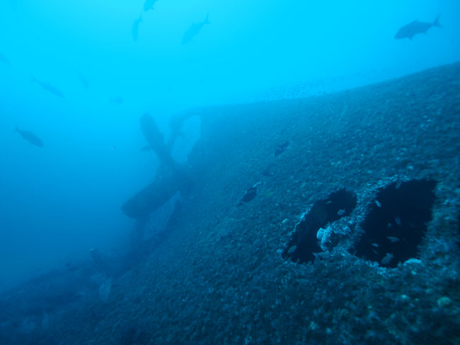
There are holes in the shell plating just forward of the propeller. This photo was taken on the lee side of the hull, which is the starboard side of the stern section, looking aft. Photo by Marc Corbett |
The propeller aperture is very similar in appearance when compared to photos of the Merak. However, it is also a fairly standard design from this era. This is looking down to the fantail at the very stern. Photo by Marc Corbett. |
The propeller is a very large four bladed bronze wheel. The rudder blade has fallen from the gudgeons. Photo is by Marc Corbett. |
Sources used to develop this web page:
1. Shipwrecks of North Carolina, Hatteras Inlet North, Gary Gentile, ISBN #0-9621453-7-8
2. Graveyard of the Atlantic, Shipwrecks of the North Carolina Coast, David Stick, ISBN #0-8078-0622-6, Version - Seventeenth printing
3. American Merchant Marine at War, www.usmm.org
4. Personal dive experience of Captain Dave Sommers, Dive Hatteras
5. NOAA drawing of shipwreck site.
6. Personal dive experience and photographs of the wreck site by Marc Corbett, Wanchese, NC
7. U-Boat.net - The best general information website about German U-boats on the web today
8. Historisches-Marinearchieve, DE - online database of all existing German U-boat KTB reports
9. Underwater Photos by Marc Corbet, Wanchese, NC.
Send mail to webmaster@divehatteras.com with
questions or comments about this web site.
Copyright © 2015
DiveHatteras llc
Last modified:
June 12, 2021